Category:Haddenham, Cambridgeshire
Jump to navigation
Jump to search
English: Haddenham is a village and civil parish in Cambridgeshire, England. In the 2001 census the parish had a population of 3,228.
village and civil parish in East Cambridgeshire, Cambridgeshire, England, UK _(SideA).jpg) | |||||
| Upload media | |||||
| Instance of | |||||
|---|---|---|---|---|---|
| Location | East Cambridgeshire, Cambridgeshire, East of England, England | ||||
| official website | |||||
 | |||||
Subcategories
This category has the following 3 subcategories, out of 3 total.
H
- Haddenham railway station (1 F)
T
Media in category "Haddenham, Cambridgeshire"
The following 200 files are in this category, out of 451 total.
(previous page) (next page)-
 A farm track on Ewell Fen - geograph.org.uk - 5165029.jpg 1,024 × 768; 877 KB
-
 A fenland bridle way - geograph.org.uk - 5164983.jpg 1,024 × 732; 873 KB
-
 A tractor on Long Drove - geograph.org.uk - 5164977.jpg 1,024 × 768; 929 KB
-
 A view from Earith Bridge - The Ouse Washes - geograph.org.uk - 6321060.jpg 5,184 × 3,888; 4.72 MB
-
 A1123 at Earith Bridge boundary - geograph.org.uk - 5118726.jpg 640 × 479; 54 KB
-
 A1123 Hill Row - geograph.org.uk - 5118712.jpg 640 × 480; 51 KB
-
 A1123 Hill Row - geograph.org.uk - 5118719.jpg 640 × 480; 49 KB
-
 A1123 Hill Row Causeway - geograph.org.uk - 2563737.jpg 1,600 × 1,200; 733 KB
-
 A1123 Hill Row Causeway - geograph.org.uk - 5118724.jpg 640 × 481; 51 KB
-
 A1123 leaving Haddenham - geograph.org.uk - 2148193.jpg 1,600 × 1,200; 997 KB
-
 A1123 near Causeway Farm - geograph.org.uk - 5118722.jpg 640 × 480; 46 KB
-
 Abandoned shed on Long Drove - geograph.org.uk - 4598747.jpg 4,320 × 3,240; 5.87 MB
-

-
 Adventurers' Head Drove byway - geograph.org.uk - 2563747.jpg 1,600 × 1,200; 746 KB
-
 Adventures' Head Drove - geograph.org.uk - 2148222.jpg 1,600 × 1,200; 962 KB
-
 Aldreth Causeway - geograph.org.uk - 4198517.jpg 3,648 × 2,736; 2.86 MB
-
 Aldreth Causeway - geograph.org.uk - 5849149.jpg 1,000 × 750; 195 KB
-
 Aldreth High Street - geograph.org.uk - 5170569.jpg 2,592 × 1,944; 1.14 MB
-
 Aldreth Road - geograph.org.uk - 2445373.jpg 800 × 531; 103 KB
-
 Aldreth Road - geograph.org.uk - 2445390.jpg 800 × 531; 106 KB
-
 Aldreth Road - geograph.org.uk - 5379222.jpg 1,600 × 1,200; 340 KB
-
 Aldreth Road - geograph.org.uk - 5848941.jpg 1,000 × 784; 162 KB
-
 Aldreth Road towards Aldreth - geograph.org.uk - 5498742.jpg 640 × 480; 61 KB
-
 Aldreth Road towards Haddenham - geograph.org.uk - 5498749.jpg 640 × 480; 57 KB
-
 Aldreth Road, Haddenham - geograph.org.uk - 5498759.jpg 640 × 480; 75 KB
-
 Aldreth Village Centre - geograph.org.uk - 5498738.jpg 640 × 480; 68 KB
-
 Aldreth village sign - geograph.org.uk - 5849128.jpg 1,000 × 998; 178 KB
-
 Aldreth, aerial 2017 - geograph.org.uk - 5468175.jpg 800 × 391; 44 KB
-
 Aldreth, along The Boot - geograph.org.uk - 5165017.jpg 1,024 × 768; 913 KB
-
 Aldreth, Caius Cottage - geograph.org.uk - 5165215.jpg 1,024 × 1,024; 1.06 MB
-
 Aldreth, cottages on the High Street - geograph.org.uk - 5165210.jpg 1,024 × 682; 836 KB
-
 Aldreth, Fen Side - geograph.org.uk - 5165160.jpg 1,024 × 732; 866 KB
-
 Aldreth, High Street - geograph.org.uk - 5165187.jpg 1,024 × 683; 889 KB
-
 Aldreth, New Cut Drain - geograph.org.uk - 5165050.jpg 1,024 × 1,024; 1.32 MB
-
 Aldreth, Stocking Lane - geograph.org.uk - 5165206.jpg 1,024 × 1,024; 1.42 MB
-
 Apple orchard, Haddenham - geograph.org.uk - 4187448.jpg 3,648 × 2,736; 2.57 MB
-
 Apple orchard, Haddenham - geograph.org.uk - 4187465.jpg 3,648 × 2,736; 2.6 MB
-
 Arable land, Aldreth - geograph.org.uk - 4198588.jpg 2,736 × 3,648; 2.48 MB
-
 Arable land, Haddenham - geograph.org.uk - 4187468.jpg 3,648 × 2,736; 2.6 MB
-
 Arable land, Haddenham - geograph.org.uk - 4187491.jpg 3,648 × 2,736; 2.58 MB
-
 Autumn cultivation near Dam Bank Bridge - geograph.org.uk - 5164971.jpg 1,024 × 768; 1.07 MB
-
 B1381 towards Earith - geograph.org.uk - 5497957.jpg 640 × 480; 51 KB
-
 B1381 towards Earith - geograph.org.uk - 5497974.jpg 640 × 480; 55 KB
-
 Back Drove - geograph.org.uk - 2563754.jpg 1,600 × 1,200; 813 KB
-
 Back Drove - geograph.org.uk - 2563811.jpg 1,600 × 1,200; 704 KB
-
 Back Drove heading east from Long Drove - geograph.org.uk - 4598807.jpg 4,320 × 3,240; 5.19 MB
-
 Beet Field, Aldreth - geograph.org.uk - 4198641.jpg 3,315 × 2,063; 1.9 MB
-
 Belt of trees near Hermitage Farm, Earith - geograph.org.uk - 4598859.jpg 4,320 × 3,240; 5.41 MB
-
 Berry Fen - geograph.org.uk - 5937239.jpg 1,600 × 1,247; 466 KB
-
 Between Haddenham and Aldreth in Cambridgeshire - geograph.org.uk - 5161199.jpg 4,149 × 3,111; 2.77 MB
-
 Boat by the Sluice, Aldreth - geograph.org.uk - 4198571.jpg 3,098 × 2,686; 2 MB
-
 Bonfire field, Haddenham - geograph.org.uk - 4187489.jpg 3,648 × 2,736; 2.51 MB
-
 Bridge over Little Adventurers' Dain - geograph.org.uk - 5161026.jpg 4,320 × 3,240; 4.55 MB
-
 Bridge over Little Adventurers' Drain - geograph.org.uk - 2149121.jpg 1,600 × 1,200; 961 KB
-
 Bridge over Little Adventurers' Drain - geograph.org.uk - 2564183.jpg 1,600 × 1,200; 774 KB
-
 Bridge over New Cut Drain - geograph.org.uk - 4198713.jpg 2,249 × 3,531; 2.12 MB
-
 Butlers Drove - geograph.org.uk - 2148135.jpg 1,600 × 1,200; 999 KB
-
 Byway on Holme Fen - geograph.org.uk - 1140527.jpg 640 × 480; 101 KB
-
 Byway on Holme Fen - geograph.org.uk - 5936965.jpg 1,600 × 1,200; 400 KB
-
 Catchwater Drain - geograph.org.uk - 1708206.jpg 1,600 × 1,200; 776 KB
-
 Cattle and Cattle Egret - geograph.org.uk - 5970987.jpg 1,600 × 1,145; 350 KB
-
 Cattle on North Hill, Haddenham - geograph.org.uk - 4684254.jpg 4,320 × 3,240; 5.8 MB
-
 Cattle on the Ouse Washes - geograph.org.uk - 5983699.jpg 1,600 × 1,160; 234 KB
-
 Cereal crop east of Long Drove - geograph.org.uk - 5498681.jpg 640 × 480; 63 KB
-
 Cereal crop near Earith - geograph.org.uk - 5497967.jpg 640 × 480; 61 KB
-
-

-
 Cereal crop towards Dam Bank Bridge - geograph.org.uk - 5498711.jpg 640 × 480; 73 KB
-
 Cereal crop, Ewell Fen - geograph.org.uk - 5498724.jpg 640 × 480; 82 KB
-
 Cereal crop, Haddenham - geograph.org.uk - 5498782.jpg 640 × 480; 72 KB
-
 Chewell Lane allotments, Haddenham - geograph.org.uk - 4187511.jpg 3,648 × 2,736; 2.58 MB
-
 Chewell Lane graveyard, Haddenham - geograph.org.uk - 4187521.jpg 2,346 × 3,128; 1.79 MB
-
 Church Fen Bridge south of Aldreth - geograph.org.uk - 5161087.jpg 4,320 × 3,240; 4.22 MB
-
 Church Fen Drove - geograph.org.uk - 2039104.jpg 1,600 × 1,200; 540 KB
-
 Church Fen Drove - geograph.org.uk - 5937294.jpg 1,600 × 1,200; 329 KB
-
 Civil War fort earthworks - geograph.org.uk - 3165015.jpg 1,600 × 1,200; 687 KB
-
 Close up, Elizabeth II postbox on High Street, Aldreth - geograph.org.uk - 5500378.jpg 1,785 × 2,524; 974 KB
-
 Cottage in Haddenham - geograph.org.uk - 5498757.jpg 640 × 480; 71 KB
-
 Cottages in Aldreth High Street - geograph.org.uk - 5849139.jpg 1,000 × 804; 138 KB
-
 Cows in The Gulls - geograph.org.uk - 3195146.jpg 1,600 × 1,200; 842 KB
-
 Crop field near Willow Farm - geograph.org.uk - 5498672.jpg 640 × 480; 71 KB
-
 Crop field north of Dam Bank Drove - geograph.org.uk - 5498715.jpg 640 × 480; 90 KB
-
 Crop of maize on Dam Bank Drove near Aldreth, Cambridgeshire - geograph.org.uk - 5160730.jpg 4,320 × 3,240; 5.65 MB
-
 Cross Drove - geograph.org.uk - 2039217.jpg 1,600 × 1,200; 634 KB
-
 Cross Drove - geograph.org.uk - 2039509.jpg 1,600 × 1,200; 485 KB
-
 Cross Drove - geograph.org.uk - 2563883.jpg 1,600 × 1,200; 660 KB
-
 Cross Drove joins Lakes Drove near Aldreth - geograph.org.uk - 5161189.jpg 4,305 × 3,229; 3.43 MB
-
 Cross Drove near Aldreth - A dual carriageway^ - geograph.org.uk - 5161177.jpg 4,320 × 3,240; 4.02 MB
-
 Dairy House Drove - geograph.org.uk - 2039245.jpg 1,600 × 1,200; 653 KB
-
 Dairy House Drove - geograph.org.uk - 2039252.jpg 1,600 × 1,200; 796 KB
-
 Dam Bank Bridge - geograph.org.uk - 1708356.jpg 1,600 × 1,200; 661 KB
-
 Dam Bank Drove - geograph.org.uk - 1480618.jpg 640 × 480; 115 KB
-
 Dam Bank Drove - geograph.org.uk - 1708391.jpg 1,600 × 1,200; 653 KB
-
 Dam Bank Drove - geograph.org.uk - 5498718.jpg 640 × 480; 61 KB
-
 De-Freville Farm - geograph.org.uk - 2148021.jpg 1,600 × 1,200; 1,002 KB
-
 Derelict farmhouse at Setchell's Farm near Haddenham - geograph.org.uk - 4684342.jpg 4,320 × 3,240; 5.81 MB
-
 Ditch across Holme Fen - geograph.org.uk - 2039226.jpg 1,600 × 1,200; 850 KB
-
 Ditch across Lower Delphs - geograph.org.uk - 2149189.jpg 1,600 × 1,200; 1.15 MB
-
 Ditch across Lower Delphs - geograph.org.uk - 2563720.jpg 1,600 × 1,200; 944 KB
-
 Ditch along Adventures' Head Drove - geograph.org.uk - 2148226.jpg 1,200 × 1,600; 1.16 MB
-
 Doorway at Frog's Hall, Aldreth - geograph.org.uk - 4198615.jpg 2,475 × 3,438; 2.11 MB
-
 Downstream on River Great Ouse at Earith Bridge, 1991 - geograph.org.uk - 4323225.jpg 2,287 × 1,456; 3.22 MB
-
 Drain across Gall Fen - geograph.org.uk - 1480349.jpg 640 × 480; 130 KB
-
 Drain across the fen - geograph.org.uk - 1480429.jpg 640 × 480; 127 KB
-
 Drain alongside Cross Drove near Aldreth - geograph.org.uk - 5161119.jpg 4,320 × 3,240; 3.34 MB
-
 Drain by the road - geograph.org.uk - 1480343.jpg 640 × 480; 149 KB
-
 Drain off Long Drove - geograph.org.uk - 4598762.jpg 4,320 × 3,240; 5.72 MB
-
 Drain off Long Drove - geograph.org.uk - 5498706.jpg 640 × 480; 84 KB
-
 Duck Lane, Haddenham - geograph.org.uk - 5500387.jpg 2,848 × 2,136; 1.21 MB
-
 Earith Bridge - geograph.org.uk - 4739210.jpg 640 × 480; 91 KB
-
 Earith Bridge travellers' site - geograph.org.uk - 3164913.jpg 1,600 × 1,200; 696 KB
-
 Earith Bridge, River Great Ouse, 1991 - geograph.org.uk - 4323183.jpg 2,341 × 1,576; 3.33 MB
-
 Eight and Twenty Farm - geograph.org.uk - 5497994.jpg 640 × 480; 61 KB
-
 Electricity lines across North Fen - geograph.org.uk - 2564343.jpg 1,600 × 1,200; 679 KB
-

-
 Elizabeth II postbox on Duck Lane, Haddenham - geograph.org.uk - 5500385.jpg 2,069 × 2,515; 1.17 MB
-
 Ely Way - geograph.org.uk - 2564792.jpg 1,600 × 1,200; 641 KB
-
 Ely Way near Haddenham - geograph.org.uk - 3983958.jpg 4,320 × 3,240; 5.87 MB
-
 Ely Way nears Haddenham - geograph.org.uk - 5118704.jpg 640 × 481; 44 KB
-
 Entering Earith Bridge - geograph.org.uk - 5497978.jpg 640 × 480; 57 KB
-
 Etheldreda - geograph.org.uk - 5849051.jpg 1,000 × 784; 122 KB
-
 Fairchild's Meadow, Haddenham - geograph.org.uk - 4187476.jpg 3,648 × 2,736; 2.6 MB
-
 Farm Building, Aldreth - geograph.org.uk - 4198653.jpg 2,736 × 3,648; 2.51 MB
-
 Farm buildings, Willow Hall Farm - geograph.org.uk - 5498662.jpg 640 × 480; 61 KB
-
 Farm entrance near Haddenham - geograph.org.uk - 4062771.jpg 4,320 × 3,240; 5.95 MB
-
 Farm track, Ewell Fen - geograph.org.uk - 5498730.jpg 640 × 480; 70 KB
-
 Farmland at Adventurers' Head - geograph.org.uk - 5170591.jpg 2,592 × 1,944; 1.68 MB
-

-
 Farmland near Hermitage Farm, Earith - geograph.org.uk - 4684436.jpg 4,320 × 3,240; 5.76 MB
-
 Farmland on Ewell Fen - geograph.org.uk - 5170583.jpg 2,592 × 1,944; 1.63 MB
-
 Farmland on North Hill - geograph.org.uk - 4988822.jpg 3,648 × 2,736; 2.65 MB
-
 Farmland south of Cracknell Farm - geograph.org.uk - 5170590.jpg 2,592 × 1,944; 1.42 MB
-
 Fen Side (Track) on the edge of Gall Fen, Haddenham - geograph.org.uk - 4684421.jpg 4,320 × 3,240; 5.74 MB
-
 Fen Side - geograph.org.uk - 2039580.jpg 1,600 × 1,067; 690 KB
-
 Fen Side byway - geograph.org.uk - 2039135.jpg 1,600 × 1,200; 1.1 MB
-
 Fen Side byway - geograph.org.uk - 2563925.jpg 1,600 × 1,200; 953 KB
-
 Fen Side byway - geograph.org.uk - 2563946.jpg 1,600 × 1,200; 1.03 MB
-
 Fen Side byway - geograph.org.uk - 2564175.jpg 1,600 × 1,200; 1.08 MB
-
 Fen Side byway - geograph.org.uk - 5937249.jpg 1,600 × 1,257; 555 KB
-
 Fen Side byway - geograph.org.uk - 5937252.jpg 1,600 × 1,128; 525 KB
-
 Fen Side byway - geograph.org.uk - 5937262.jpg 1,600 × 1,200; 471 KB
-
 Fen Side byway - geograph.org.uk - 5937299.jpg 1,600 × 1,172; 446 KB
-
 Fen Side byway leaving Looe Way - geograph.org.uk - 2039574.jpg 1,600 × 1,200; 1.04 MB
-
 Fen Side track - geograph.org.uk - 2148069.jpg 1,600 × 1,200; 1.18 MB
-
 Fen Side track - geograph.org.uk - 2148173.jpg 1,600 × 1,200; 1.25 MB
-
 Fen Side track - geograph.org.uk - 2148179.jpg 1,600 × 1,200; 1.13 MB
-
 Fen Side track - geograph.org.uk - 2148187.jpg 1,600 × 1,200; 1.25 MB
-
 Fenland by Old West River - geograph.org.uk - 1708344.jpg 1,600 × 1,200; 698 KB
-
 Fenland by Old West River - geograph.org.uk - 2563708.jpg 1,600 × 1,200; 790 KB
-
 Fenland ditch - geograph.org.uk - 1140293.jpg 640 × 480; 136 KB
-
 Fenland ditch - geograph.org.uk - 1140377.jpg 640 × 480; 105 KB
-
 Fenside south of Haddenham - geograph.org.uk - 4209374.jpg 4,320 × 3,240; 5.68 MB
-
 Field by New Cut Drain - geograph.org.uk - 5937238.jpg 1,600 × 1,200; 445 KB
-
 Field by the Great Ouse - geograph.org.uk - 5936821.jpg 1,600 × 1,200; 292 KB
-
 Field near Aldreth - geograph.org.uk - 5498734.jpg 640 × 480; 70 KB
-
 Fields by Galls Farm - geograph.org.uk - 2564196.jpg 1,600 × 1,200; 714 KB
-
 Fields by Hundred Foot Bank - geograph.org.uk - 5983704.jpg 1,600 × 1,200; 452 KB
-
 Fields by Ouse Washes - geograph.org.uk - 4636891.jpg 1,600 × 1,200; 791 KB
-
 Flat Bridge - geograph.org.uk - 3195091.jpg 1,600 × 1,200; 1,023 KB
-
 Flat Bridge - geograph.org.uk - 5674554.jpg 3,264 × 1,840; 2.27 MB
-
 Flood bank, New Bedford River - geograph.org.uk - 5497958.jpg 640 × 480; 48 KB
-
 Flood bank, New Bedford River - geograph.org.uk - 5497970.jpg 640 × 480; 74 KB
-
 Floodbank at Aldreth - geograph.org.uk - 4198557.jpg 3,648 × 2,736; 2.6 MB
-
 Flowering hawthorn bush on Pingle Way - geograph.org.uk - 3983986.jpg 4,320 × 3,240; 5.45 MB
-
 Footpath along River Great Ouse - geograph.org.uk - 2563696.jpg 1,600 × 1,200; 919 KB
-
 Footpath along River Great Ouse - geograph.org.uk - 3194918.jpg 1,600 × 1,200; 808 KB
-
 Footpath to Haddenham - geograph.org.uk - 5379202.jpg 1,600 × 1,200; 497 KB
-
 Ford by the river, Aldreth - geograph.org.uk - 4198545.jpg 2,279 × 3,038; 2.01 MB
-
 Former Ely and St Ives Railway - geograph.org.uk - 2564442.jpg 1,600 × 1,200; 953 KB
-

-
 Forty Pole Drove - geograph.org.uk - 2563893.jpg 1,600 × 1,200; 1.06 MB
-
 Forty Pole Drove near Haddenham - geograph.org.uk - 4209415.jpg 4,320 × 3,240; 5.65 MB
-
 Foulmire Drove crossing Hill Row Doles and Small Fen - geograph.org.uk - 5158011.jpg 4,320 × 3,240; 5.72 MB
-
 Front door, St George's Farm, Haddenham - geograph.org.uk - 539024.jpg 2,000 × 3,008; 3.1 MB
-
 Furrowed field - geograph.org.uk - 2563682.jpg 1,600 × 1,200; 724 KB
-
 Gall Fen - geograph.org.uk - 2148184.jpg 1,600 × 1,200; 1.09 MB
-
 Gateway to Parkes Farm - geograph.org.uk - 5498740.jpg 640 × 480; 64 KB
-
 Glebe Way, Haddenham - geograph.org.uk - 4598648.jpg 4,320 × 3,240; 5.86 MB
-
 Granger's Drove - geograph.org.uk - 2563817.jpg 1,600 × 1,200; 787 KB
-
 Granger's Drove joins Back Drove near Aldreth - geograph.org.uk - 5161013.jpg 4,320 × 3,240; 4.9 MB
-
 Granger's Drove near Aldreth in Cambridgeshire - geograph.org.uk - 5160717.jpg 4,320 × 3,240; 5.93 MB
-
 Granger's Drove near Aldreth, Cambridgeshire - geograph.org.uk - 5160709.jpg 4,320 × 3,240; 6.04 MB
-
 Grassy field - geograph.org.uk - 1480366.jpg 640 × 480; 127 KB
-
 Gravel Pit Drove (byway) - geograph.org.uk - 5498703.jpg 640 × 480; 72 KB
-
 Gravel Pit Drove - geograph.org.uk - 2149201.jpg 1,600 × 1,200; 1.12 MB
-
 Gravel Pit Drove - geograph.org.uk - 2563715.jpg 1,600 × 1,200; 819 KB
-
 Gravel Pit Drove - geograph.org.uk - 4598792.jpg 4,320 × 3,240; 5.52 MB
-
 Grazing Land - geograph.org.uk - 4988799.jpg 3,648 × 2,736; 2.91 MB
-
 Grazing on the flood plain - geograph.org.uk - 4198605.jpg 2,997 × 2,248; 2.21 MB
-
 Great Mill Tower and Great Mill House in Haddenham - geograph.org.uk - 5161217.jpg 4,320 × 3,240; 3.25 MB
-

-
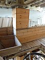 Great Mill, Haddenham - bin floor - geograph.org.uk - 5694829.jpg 480 × 640; 74 KB
-

-

-

-

-
 Great Mill, Haddenham - geograph.org.uk - 5695737.jpg 480 × 640; 81 KB
-
 Great Mill, Haddenham - ground floor - geograph.org.uk - 5692585.jpg 480 × 640; 98 KB
-
 Great Mill, Haddenham - mainshaft - geograph.org.uk - 5695741.jpg 640 × 480; 70 KB
-


_-_geograph.org.uk_-_5498785.jpg)


_on_the_edge_of_Gall_Fen,_Haddenham_-_geograph.org.uk_-_4684421.jpg)


_-_geograph.org.uk_-_5498703.jpg)


